Skip to content

For general aviation pilots · Live on the App Store

Weather, decoded
for pilots.

METARs, TAFs, NOTAMs, and radar — read in plain English, organized around your personal minimums. iPhone and iPad, iOS 18 and up.

iOS 18+ · iPhone & iPad · Built by pilots

KSFO San Francisco Intl

VFR

Wind from 280° at 9 kt. Visibility 10 SM. Few clouds at 1,500 ft; Scattered clouds at 20,000 ft. Temperature 18°C, dewpoint 12°C. Altimeter 30.01.

KSFO 121856Z 28009KT 10SM FEW015 SCT200 18/12 A3001

Sample observation · Observed 18:56Z

The same decoding the app runs — live in your browser.

What it does

Four products, one screen.

KOAK

VFR

Wind from 300° at 12 kt. Visibility 10 SM. Few clouds at 2,000 ft. Nineteen Celsius.

METAR KOAK 121853Z 30012KT 10SM FEW020 19/11 A3000

01 · Current observations

METARs, in plain English

Every observation decoded by default. Wind, visibility, ceiling, staleness — surfaced where they need to be. Raw text on tap, never buried more than that.
KBOS · TAF

12Z – 18Z

At 1512Z — MVFR. Wind 200° at 15, gusting 22. Broken at 2,500.

02 · Forecasts

TAFs on a scrubbable timeline

Drag a needle along the forecast window. The screen tells you, in English, what is expected at the moment you stop. International TAFs supported.

RWY 10R/28L CLSD

High impact

Runway closed for construction until 2200Z.

TWY B CL LGT U/S

Low

OBST CRANE 1.2 NM SE

Low

03 · Notices

NOTAMs by impact

FAA NOTAMs filtered to your watched stations and ordered by how much they actually matter. The runway closure surfaces; the obstruction lights across the bay do not.

04 · Map

Radar, SIGMETs, PIREPs

NEXRAD in the US and RainViewer worldwide, with a time scrubber. Watched-station markers carry their current FAA category. PIREPs within 50 NM, last two hours.

In the cockpit

Built around how pilots actually brief.

01

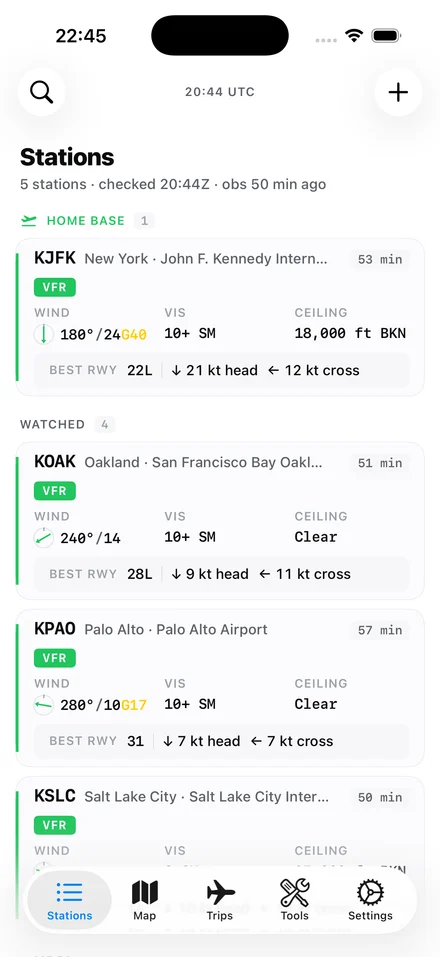
Decoded by default.

Every weather product shown in plain English first. Raw text on tap. Stationweather buries decoding behind a toggle; SkyFeed leads with it.

SkyFeed Stations Home screen — five watched airports including KJFK, KOAK, KPAO, and KSLC, each with FAA category pills, wind, visibility, ceiling, and best-runway recommendations.

02

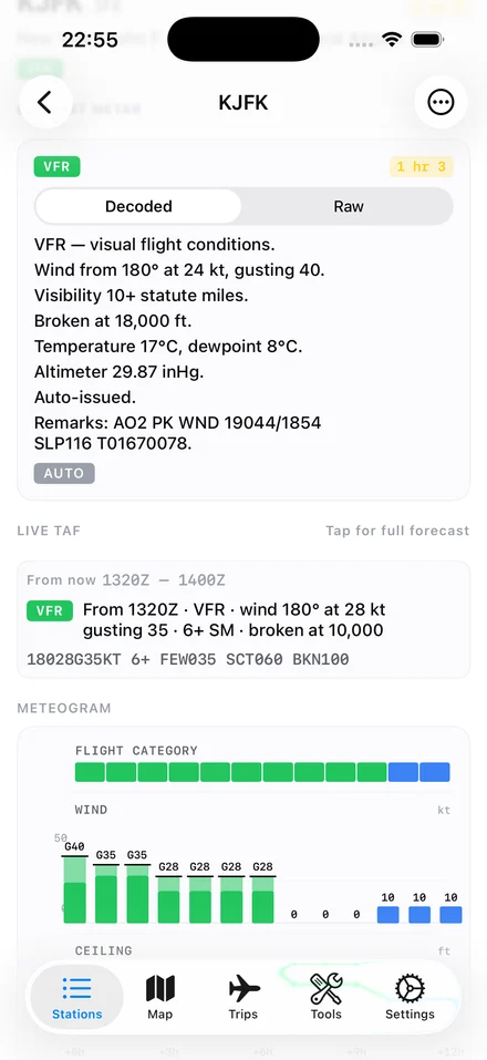
Personal minimums everywhere.

Your limits are the first-class organizing principle for every screen — verdicts, color tints, alerts, brief checks. Nobody else does this end-to-end.

SkyFeed Station Detail for KJFK — VFR pill, decoded METAR at the top, Live TAF preview below, and a twelve-hour meteogram of flight category, wind, and ceiling.

03

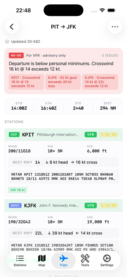
A brief that gives a verdict.

Departure, destination, alternate — checked against your minimums, with the go / no-go advisory at the top and the reasons listed under it.

SkyFeed Brief screen for KPIT → KJFK — a red NO-GO advisory at the top, then both stations listed with full METARs and best-runway notes.

04

The picture, when you want it.

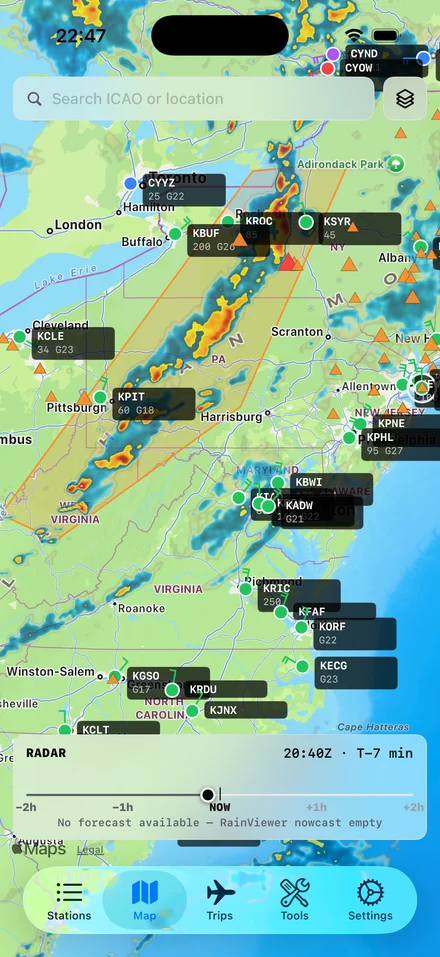
NEXRAD radar with a time scrubber — RainViewer worldwide — plus SIGMETs and PIREPs. Your watched stations sit on the map in their current category colors.

SkyFeed Map view on iPhone covering the US Northeast — NEXRAD radar layer showing a band of orange and red cells, with watched-station markers in their FAA category colors overlaid.

Pilot calculators

Seven tools. No signup.

The same seven calculators that ship inside the app, on the web — for the times you want a number without unlocking the phone. Try the decoder with any METAR.

Try it — METAR decoder

Common questions

Before you download.

If something else is unclear, the answer is probably in Features.

01 What is SkyFeed?

SkyFeed is an iOS aviation weather app for general aviation pilots. It shows METARs, TAFs, NOTAMs, and radar — decoded into plain English by default and organized around your personal minimums. iPhone and iPad, iOS 18 and up.

02 Who is it for?

Private and IFR-rated pilots flying piston singles or twins, typically 100–500 hours. Student pilots in particular benefit from the plain-English decoding. It is not built for Part 121/135 commercial operations, drone work, or non-pilot enthusiasts.

03 How is it different from Stationweather or ForeFlight?

Stationweather buries decoded weather behind a toggle; SkyFeed leads with the decoded sentence and tucks the raw text underneath. ForeFlight is a full EFB with charts, plates, and flight planning; SkyFeed is just the weather and brief tools. They solve different problems.

04 Does it work offline?

Yes. Watched stations and last-known data are cached. If you lose signal in the cockpit, you keep seeing the last METAR and TAF you had, with a clear staleness indicator. The app never errors out due to no signal.

05 What weather sources does it use?

METARs and TAFs from NOAA Aviation Weather Center. NOTAMs from the FAA NOTAM API. Radar from NOAA NEXRAD (US) and RainViewer (worldwide). Sun and twilight from the NOAA algorithm. Airport catalog from OurAirports.

06 Does it work outside the United States?

Mostly. METARs and TAFs work worldwide via NOAA's Aviation Weather Center. Radar is NEXRAD in the US and RainViewer everywhere else. NOTAMs are US-only in v1. International TAFs (EGLL, EHAM, and similar) are parsed correctly.

07 Will there be an Android version?

Not in v1. iOS-only is a deliberate choice — going deep on iPad master-detail and multi-column layouts is the differentiator. Android is possible later but is not on the v1 roadmap.

Download

On the App Store.
iOS 18 and up.

iPhone and iPad. No accounts, no signup. The app is the whole product.

The newsletter

Occasional product updates and aviation-weather tips. Email only. No spam.

Unsubscribe in one click. No third parties.